ICEYE PRODUCTS
Product Types
Info
The section "An Overview of SAR Imaging" provides a review of the technologies mentioned here.
There are two basic forms of ICEYE images: complex images in the slant plane and amplitude images projected to the ground surface. Details about the formats of these products are provided in 'Product Formats'.
Complex Images
SAR complex images contain pixels that have both amplitude and phase values. They are produced at full resolution and are projected in the inclined direction of illumination, called the slant plane. Since complex images retain phase information, they can be used to produce numerous SAR products like coherent change detection images and precise surface motion measurements.
Amplitude Images
These are the familiar SAR gray-scale images with amplitude-only pixels. They are “multi-looked” to reduce the grainy effect of speckle, at the cost of slightly lower resolution. Amplitude images are projected to the ground surface and can be oriented with respect to the sensor or produced on an ellipsoid-based map projection. For historical reasons our amplitude images are associated with the acronym GRD which stands for Ground Range Detected. This term may change in the future to be something more meaningful.
Types of SAR Collection
Our first set of satellites operate in one of two primary imaging modes called Strip Mode and Spot Mode. These are available in both right and left-looking configurations. The design flexibility of our satellites allows their imaging modes to be continually evolved. We will be adding more modes, and more flexible illumination patterns, in future versions. A recent addition is the introduction of a wide area imaging capability that utilises electronic beam steering. This is called Scan Mode A summary of the imaging modes is listed in An Overview of SAR Imaging.
Strip Mode
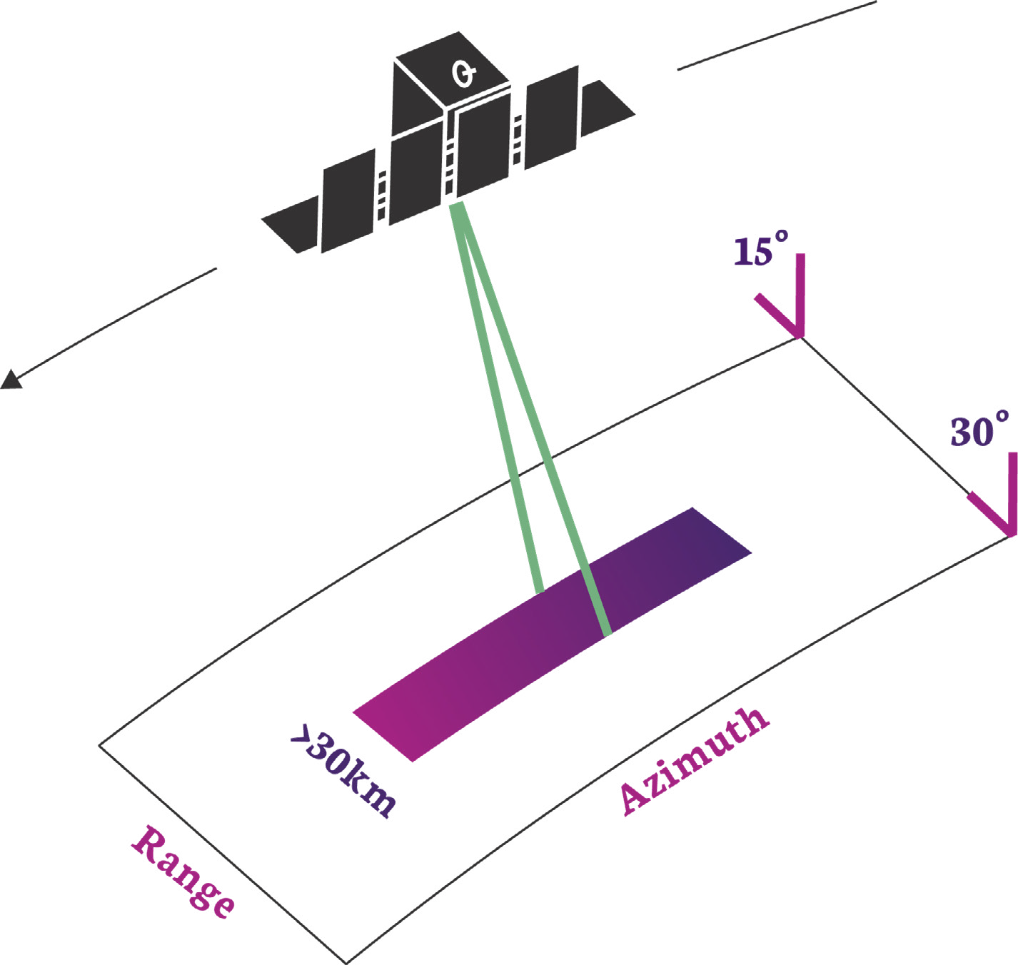 In this mode the ground swath is illuminated with a continuous sequence of pulses while the antenna beam is fixed in its orientation. The beam is pointed off to the side of the satellite at an angle broadside to the satellite flight path. This results in a long image strip parallel to the flight direction.
ICEYE standard Strip products have a ground resolution of 3m in range and azimuth and cover an area of 30km (range) by 50km (azimuth). The strip length can be tailored up to a length of 500 km, in increments of 50 km.
Spot Mode
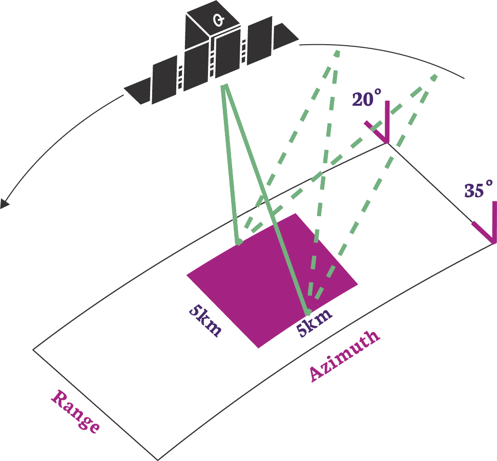 In Spot mode the radar beam is steered to illuminate a fixed point. This increases the illumination time and therefore increases the length of the synthetic aperture and improves azimuth resolution. Spot mode uses the maximum 300 MHz pulse bandwidth to achieve a 0.5m slant range resolution (here is an explanation of where this comes from.).
ICEYE's standard Spot collection covers an area of 5km x 5km with a ground resolution of 1m and has 4 independent looks that are useful for suppressing speckle effects and increasing the image quality. Alternatively, customers can now request an extended area spot image. This is a standard Spot collection that trades the number of looks to increase the scene size whilst preserving the resolution. The Spot extended area collection has a scene size of 15km x 15km at 1m ground resolution using a single independent look.
Scan Mode
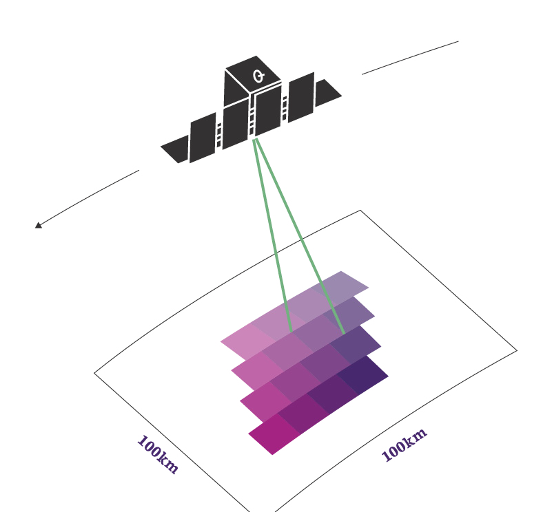 This mode uses the phased array antenna to create multiple beams in the elevation direction. This beam steering means that points on the ground are not illuminated for as long which reduces the resolution of a Scan product compared to Spot or Strip modes. Conventionally, ground points are illuminated by different parts of the radar beam resulting in brighter and darker regions in the image. We compensate for this by also steering the radar beam sideways during each burst of radar pulses resulting in an overall improvement in image quality. This technique is called Terrain Observation by Progressive Scans (TOPS or TOPSAR1). Our Scan product produces imagery that covers an area of 100km x 100km with a resolution better than 15m. The length of a Scan product can be increased to 300km.
References
-
F. De Zan and A. Monti Guarnieri. Topsar: terrain observation by progressive scans. IEEE Transactions on Geoscience and Remote Sensing, 44\(9\):2352–2360, 2006. doi:10.1109/TGRS.2006.873853. ↩